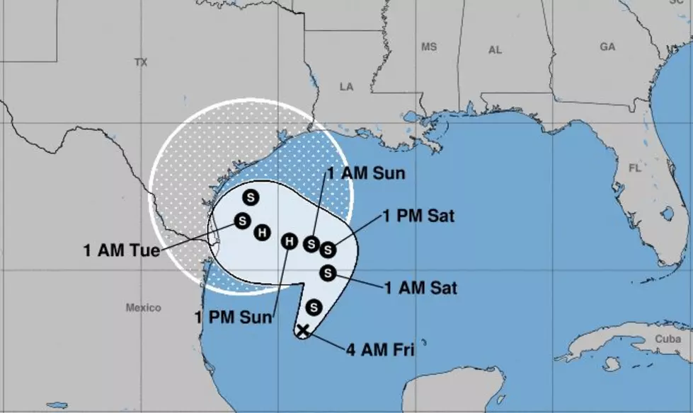
System in the Gulf Forecast to Become a Hurricane
We are still in the part of the Hurricane Season that is known around here as Louisiana "Primetime". Basically it's the four to six week period surrounding the climatological peak of the hurricane season which is September 10th. History has shown that this time of the year is the most likely time when Louisiana's coastline could be affected by a tropical storm or hurricane.
The reason for our tropical concerns this morning is Tropical Depression 22. By later today we could be referring to the system as Tropical Storm Wilfred. As of the 0400CDT Advisory from the National Hurricane Center, the center of circulation for TD 22 was located about 285 miles southeast of the mouth of the Rio Grand River.
The system was producing sustained winds of 35 mph which is just below the tropical storm threshold of 39 mph. The system is forecast to become a tropical storm later today. It is also forecast to become a hurricane over the weekend.
That part of the forecast is fairly cut and dried. The track forecast for this system is not clear at all. That is why you'll want to check back with us often over the weekend for adjustments and updates to the forecast.
Most of the tropical track model guidance suggests the system will begin moving generally northward at a very slow speed. The system will then begin a westward track that could bring it near the Texas/Mexico coastline by Tuesday. From there the system could begin to slide up the Texas coast or move onshore. The forecast is just too uncertain at this time.
Regardless of what the forecast may or may not suggest, anytime there is a tropical system in the Gulf of Mexico you need to pay attention. We've seen with recent storms a propensity for rapid strengthening and last-minute track changes. So, be weather aware this weekend. Again, let's prepare for the worst and hope for the best.
Top 10 Best Places To Retire (According to Wallethub)
More From 97.3 The Dawg


