Tropical Depression 9 Forms In Gulf Of Mexico [Updated]
[Updated 8/29/16 4:00 AM CDT]
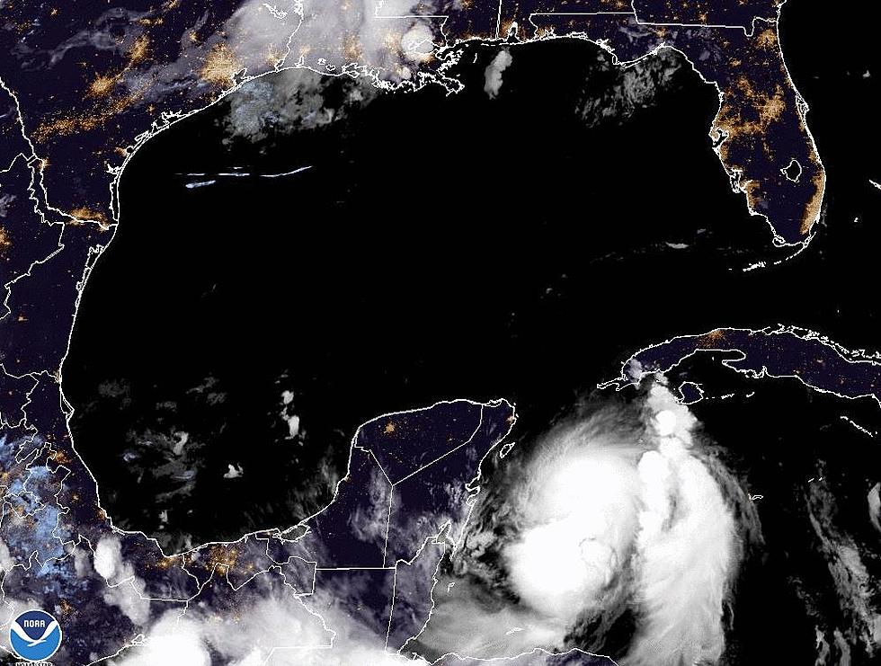
At the 4 AM Update on Tropical Depression 9 the National Hurricane Center characterized the system as "poorly organized". The depression was moving into the southeastern Gulf of Mexico this morning and conditions for strengthening should improve during the day today.
Here is the basic information about the system as reported by the Hurricane Center:
LOCATION...23.5N 83.9W
ABOUT 155 MI...245 KM WSW OF KEY WEST FLORIDA
ABOUT 95 MI...155 KM WNW OF HAVANA CUBA
MAXIMUM SUSTAINED WINDS...35 MPH...55 KM/H
PRESENT MOVEMENT...W OR 275 DEGREES AT 9 MPH...15 KM/H
MINIMUM CENTRAL PRESSURE...1007 MB...29.74 INCHES
The system's westward motion will continue for most of the day with a gradual turn to the west northwest and eventually northwest by Tuesday. Tropical forecast models continue to suggest the system will eventually take a northeastern turn later this week. Should those forecast models be reliable this would put a landfall of the system on the Florida Coast between Panama City and Tampa Bay either late Thursday or early Friday.
The Hurricane Center's forecast does call for Tropical Depression 9 to become a tropical storm by early Tuesday morning. Whether system will be Hermine or Ian is dependent on how swiftly another tropical depression, TD 8, intensifies off the North Carolina coast.
[Updated 8/28/16 4:00 PM CDT] The National Hurricane Center has upgraded INVEST 99L to a tropical depression. As of 4 PM the forecasters said the system had sustained winds of 35 MPH and was moving on a westerly track at 9 MPH.
This general westward motion is expected to continue the next 24 to 48 hours with a gradual decrease in forward speed. After that time the system is expected to take a more northerly course and eventually a more northeasterly track.
There is a basic agreement among most of the tropical tracking models for the next 24 to 48 hours. After that time frame there is a bit of variance in where the system will begin to take a northerly turn. The intensity forecasts do call for the this system to reach tropical storm status by as early as Monday. The Hurricane Center's current forecast does not call for the system to reach hurricane status before making landfall.
The current projected landfall for the system is anywhere from the Florida/Alabama boundary to the west extending as far to the east as Fort Myers Florida. So the degree of uncertainity in the forecast is extensive.
Updates from the Hurricane Center will be issued every six hours. You can see the very latest official update on the system right here.
[Original Story 08/28/16 8:00 AM] It seems as if we've been reporting on what has been labeled as INVEST 99L for the past 18 months. It's only been a couple of weeks actually. We first started following this system when it came off the African Continent as a tropical wave.
The system has been slowly moving through the Bahamas toward South Florida over the weekend and is poised to emerge into the very warm waters of the Gulf of Mexico. The latest advisory on the very disorganized system suggested that the probability of at least a tropical depression forming in the next five days was becoming more likely.
For residents of South Louisiana a tropical anything would be very bad news. The recent heavy rains are still creating flood issues for a large part of the I-10 corridor. It is feared any significant rainfall would exacerbate that situation to another very dangerous level.
As of early Sunday morning the tropical tracking models were suggesting the system would in fact enter the Gulf of Mexico. Forecasters believe that conditions in the Gulf will be conducive for the system to strengthen. For now, the best guess on a storm track takes the system between Key West Florida and Cuba during the day Sunday.
Once in the Gulf forecasters believe the system will take a more northerly track. Many of the tropical models then take the system off to the east and into Florida. However, there is still enough disagreement in the models that a right turn into Florida is not a sure thing.
The intensity forecast is is even more up in the air than the track forecast. Some of the intensity models suggest at least a tropical depression. Most of the models are going a tad stronger with a tropical storm. Then there are the models that suggest at least a minimal hurricane before landfall. The intensity will be dependent on just how long the system stays over water.
While current forecast scenarios suggest that Louisiana might receive only minimal effects from this system it is still far to early to let down your guard. We urge you to monitor local weather casts and come back to this website often for the latest updated information.
More From 97.3 The Dawg


