
Ida Continues to Weaken as it Moves Out of Louisiana
The National Hurricane Center is continuing to monitor the progress of Ida across Southeastern Louisiana. The storm is considerably weaker at this time of day than it was just a few hours ago at landfall. Granted that landfall took place near Port Fourchon around Noon on Sunday, it feels as if it has been a lifetime since that time and now.
Here is the Hurricane Center's 0400 CDT Advisory.
...IDA NOW A TROPICAL STORM OVER SOUTHWESTERN MISSISSIPPI...
...DANGEROUS STORM SURGE, DAMAGING WINDS, AND FLASH FLOODING
CONTINUE OVER PORTIONS OF SOUTHEASTERN LOUISIANA AND SOUTHERN
MISSISSIPPI...
SUMMARY OF 400 AM CDT...0900 UTC...INFORMATION
----------------------------------------------
LOCATION...31.0N 90.8W
ABOUT 95 MI...155 KM SSW OF JACKSON MISSISSIPPI
ABOUT 50 MI...75 KM NNE OF BATON ROUGE LOUISIANA
MAXIMUM SUSTAINED WINDS...60 MPH...95 KM/H
PRESENT MOVEMENT...N OR 355 DEGREES AT 8 MPH...13 KM/H
MINIMUM CENTRAL PRESSURE...990 MB...29.24 INCHES
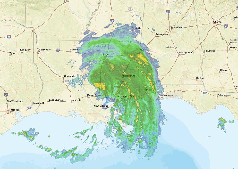
The latest radar scans from the National Weather Service radar stations suggest that most of the heavier rain associated with Ida has just about moved out of the state. Only the extreme northeast tip of the southeastern corner of the state was still reporting very heavy showers as of early this morning.
That doesn't mean portions of the state won't see some wrap-around rain bands trailing Ida's center of circulation as it moves northward into Mississippi later this afternoon.

National Weather Service Office in New Orleans/Baton Rouge estimates that many locations in southeastern Louisiana have received more than eight inches of rain in the past twelve hours. Those numbers are just estimates and certainly, those totals could be significantly higher in areas of the state that were near or just east of the storm's center of circulation.
Flooding will remain a major issue for first responders seeking to move into damaged areas this morning to assess damage and aid in rescue and recovery operations.

The Hurricane Center's forecast suggests that Ida will weaken further over the course of the day and will likely be downgraded to tropical depression status by later this evening. It is expected to continue to bring heavy downpours to parts of Mississippi, Alabama, Florida, and the remainder of the Gulf South for the next few days.

Elsewhere in the tropics, there are five other areas of concern. One is Tropical Storm Julian which has now been classified as extra-tropical. It is in the north Atlantic and expected to dissipate. Tropical Depression 10 also remains in the middle of the Atlantic and is not anticipated to pose a threat to any landmass at this time.
Just off the Eastern Seaboard of the United States, there is an area of disturbed weather forecasters are watching. However, the probability of tropical generation is unlikely at this time. Meanwhile, just off the coast of Africa, a robust tropical wave is moving off the land and into the ocean. This system is given an 80% chance of strengthening over the next five days and will likely be the next storm system we will need to watch closely.
And perhaps, while it's not the most likely scenario at this time, there is another area of disturbed weather that forecasters will be watching along the coasts of Nicaragua, Honduras, and Belize. You might recall, that was where "Ida was supposed to go" according to early forecasts from last week.
Of course, all of these areas of disturbed weather are in the category of "wait and see" as far as their strengthening or better organization is concerned, at least at this time.
Seven Crazy Louisiana Town Names Explained
More From 97.3 The Dawg


