
Tracking Laura – 4 AM Update on the Path of the Storm
We have been watching the tropical entity known as Laura for most of the past two weeks. We've followed what was once a small gathering of clouds and thunderstorms across the Atlantic to its position now in the southeastern Gulf of Mexico. It is from that position that forecasters with the National Hurricane Center believe that Laura is going to make a run at the northern Gulf Coast.
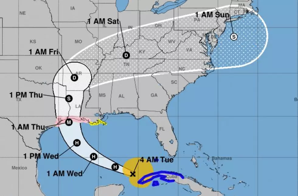
The 0400 CDT Advisory from the National Hurricane Center put the center of Tropical Storm Laura's circulation just off the eastern tip of Cuba. That's approximately 680 miles southeast of Lake Charles Louisiana, That part of the coast that is the unfortunate bullseye in Laura's projected path.
The storm is expected to reach hurricane status as it moves across the Gulf of Mexico during the day today. If the forecast models and timing are correct Laura could be making landfall very near the Texas/Louisiana line later in the day on Wednesday or in the early morning hours of Thursday.
Forecasters believe Laura will be a category 3 storm on the Saffir-Simpson Scale at landfall. That would mean wind speeds of at least 111 mph. The storm will also bring storm surge to the coast of 10 to 15 feet. Forecasters also believe some areas of Louisiana and southeast Texas could receive more than one foot of rainfall.
We remind you to not focus on the point of landfall with this system. Hurricane-force winds and tropical-storm-force winds will extend outward from the storm's center of circulation. The storm will also be a prodigious rain producer as it moves across the coast and inland. Some areas could see between 10 and 15 inches of precipitation. So, localized flashed flooding will be a possibility.
Eight Items In Every South Louisiana Pantry
More From 97.3 The Dawg


