Hurricane Beryl – Where Might It Go?
[Updated 0500 CDT] The National Hurricane Center says that Beryl has reached hurricane status. This makes the system the 2018 Hurricane Season's first hurricane. Maximum sustained winds were 75 mph, just one mile an hour over the threshold to obtain hurricane strength. Beryl was moving westward at 14 mph.
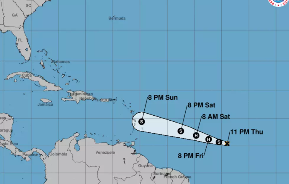
[Original Story 0200 CDT] The second named tropical system of the 2018 Hurricane Season has formed in the Atlantic Ocean. Early this morning Tropical Storm Beryl was located at 10.4 N by 44.0 W or about 1200 miles east of the islands of the Lesser Antilles. The official track forecast from the National Hurricane Center brings the system close to the island chain by Sunday night.
The storm could actually reach hurricane strength by later today so watches and warnings for those islands could be coming as early as this afternoon.
About half of the tropical forecast models, the spaghetti models if you will, pull the system in close proximity to the Gulf of Mexico by early next week. The other half of the models peel the system off to the right and keep the storm out at sea.
One thing the spaghetti models don't really show that well is the potential for this system just fall apart. Forecasters with the Hurricane Center do believe that atmospheric conditions the system will be moving into over the next few days could cause it to weaken and fall apart before it even gets to the outer islands.
Should Beryl survive the weekend we will then have a better idea of whether the system will continue on a track that brings it into the Gulf of Mexico or if it will move parallel to the East Coast of the United States. Regardless any call to action as a result of Beryl would still be many days away if a call to action even becomes necessary.
More From 97.3 The Dawg


