
Tropical Systems Could Pose a Problem for the Gulf of Mexico
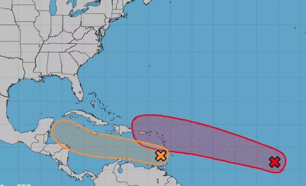
One of two tropical waves currently being monitored in the Tropical Atlantic Basin could have the potential to become a source of trouble for residents along the Gulf Coast of the United States early next week. As of now, forecasters with the National Hurricane Center are currently monitoring two different systems. One in the Caribbean Sea, the other several hundred miles southwest of the Cabo Verde Islands.
The system that's furthest away is currently showing the most signs of strengthening. In fact, the National Hurricane Center has given this system, they call it Invest 98L, a 70% probability of becoming a tropical cyclone over the next five days. The track forecast for this system suggests a path that would carry the storm to the northern edges of the Caribbean Sea over the next five days. Those with interests in the Virgin Islands and Puerto Rico should monitor this system quite closely.
There is a possibility this system could enter the Gulf of Mexico as well. Although track model forecasts suggest that Invest 98L might take more of a right-hand turn once it gets closer to the U.S. mainland. Still, interests in the Bahamas and South Florida will want to keep a watchful eye on the tropics for next week.
The second system, the one that's actually centered in the Caribbean Sea and designated by the Hurricane Center as Invest 97L is the one that we, the residents of the Gulf Coast, should be monitoring. Forecasters are giving this system a 60% probability of strengthening into a tropical cyclone. The current track forecast from the Hurricane Center brings this system very close to the Yucatan Peninsula over the weekend.
Tropical model forecasts seem to push this system further south than the solution the Hurricane Center track projection depicts. However, conditions over the Caribbean should be favorable for the system to develop further. Also, the systems forward momentum should slow down considerably over the next few days allowing it more time to strengthen.
Whichever one of these systems achieves tropical storm status first will be given the name Laura. The next system to earn a name would be called Marco. Yes, should these two systems both earn names it will be the earliest an "L" named storm and an "M" named storm has occurred in a given hurricane season.
There is still plenty of time and distance between these systems and any major landfall so, our best advice is to stay informed, make sure you're prepared now, and hope you'll never need those plans.
What You Need to Prepare Your Dog for a Road Trip
More From 97.3 The Dawg


