
Track of Tropical Storm Eta Shifts Again
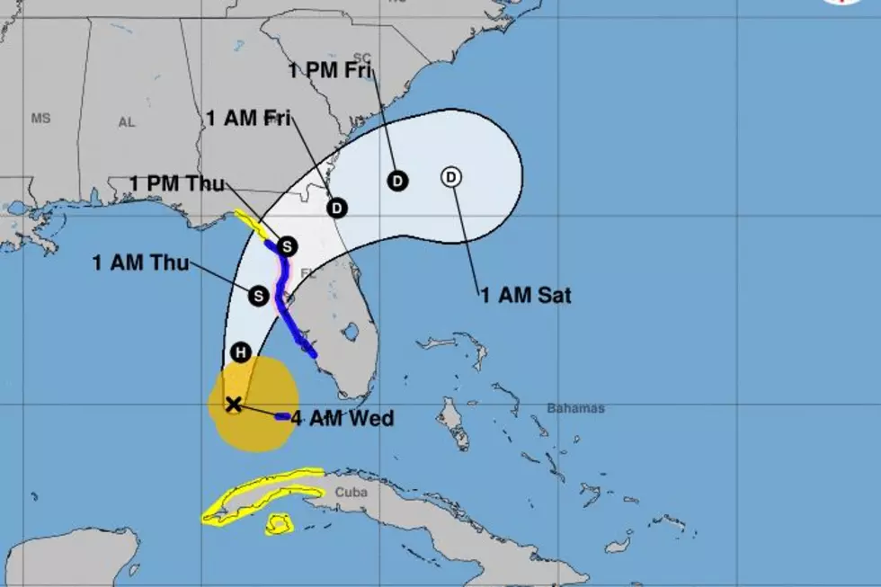
The forecast track of Tropical Storm Eta has shifted again. This time everything that's old is new again. In other words, the system which was originally forecast to impact the west coast of Florida between Appalachicola and Tampa Bay will now likely impact Florida in exactly that location. Yesterday and Monday some of the forecast tracks had shifted the storm's path a lot further north and a lot closer to Louisiana.
The most recent forecast update from the National Hurricane Center puts the circulation of Eta about 225 miles southwest of Tampa Florida. The system was moving to the north at 12 mph. The maximum sustained winds reported by hurricane hunter aircraft were estimated to be 70 mph. That is just under category 1 hurricane strength.
Forecasters do believe that Eta will become a hurricane again later today. That time as a category 1 storm will be short-lived as the system encounters a hostile environment for development as it moves to the north and eventually the northeast.
The tropical guidance models which had been a mishmash of confusing paths the past couple of days have now suddenly zeroed in on almost a singular solution. Almost all of the reliable tropical guidance models bring the storm onshore in Florida just north of Tampa Bay as a strong tropical storm by Thursday afternoon.
Tropical Storm Theta is not expected to cause any problems in the far eastern Atlantic. It should eventually move toward Portugal as a remnant low-pressure system over the weekend.
While in the Caribbean, a tropical wave there has been given an 80% probability of becoming a tropical cyclone between now and Sunday. This system is tracking to the west southwest and should impact Nicaragua and Honduras over the weekend. Let us hope that the storm-damaged areas of those nations will not have to deal with a strong tropical system. They're still assessing the damage created by Hurricane Eta just last week.
10 Ingredients to Make Your Gumbo Stand Out
More From 97.3 The Dawg


