
Tropical Storm Eta Forms in the Caribbean
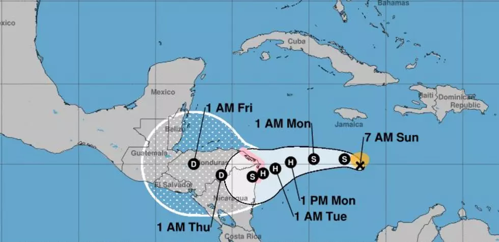
Late Saturday forecasters at the National Hurricane Center upgraded an area of disturbed weather in the Caribbean Sea to tropical storm status. The name that was given to this, the latest tropical cyclone of the seemingly neverending hurricane season of 2020 was Eta.
As of now, the storm is a minimal tropical storm with maximum sustained winds of only 40 mph. However, the system has shown signs of strengthening and the forecast does call for Eta to become a Hurricane as it nears the coast of Central America in the middle of the week.
The current track guidance on the system from the National Hurricane Center suggests the system will make landfall near the border of Honduras and Nicaragua. Unfortunately, the forecast also suggests that the system will stay in that general area for several days. This could bring life-threatening floods and rainfall to those nations.
There also seems to be some conjecture by at least some of the tropical forecast models that Eta or its tropical remnants could reappear back over the warm waters of the Caribbean and restrengthen. If that were to happen, it would be at least a week down the road, and between now and then the longer-range forecast models could be fine-tuned.
12 Incredible Facts about Stops Along I-10
More From 97.3 The Dawg


